

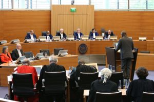
 Last weekend’s judgment in the “Dispute concerning delimitation of the maritime boundary between Ghana and Côte d’Ivoire in the Atlantic Ocean” by the International Tribunal for the Law of the Sea (“ITLOS”) is bound to enjoy the spotlight and court both public and media attention at least for the next couple of days, and it should! The implications of the judgment make it a topic of grave national interest because the area which was being claimed by Côte d’Ivoire is rich in oil and gas resources. Perhaps, interest in the judgment was further piqued because it arrived shortly after the government disclosed that its flagship free Senior High School policy would be funded by the country’s petroleum revenues. As a student of Public International Law and Natural Resource law, the judgment was of particular interest to me. Theoretically, understanding the matters around which the dispute evolved requires knowledge of Public International Law, specifically an area of it known as The Law of the Sea. Practically, some knowledge of geography, geodesy or science makes for a more intelligent appreciation of the issues at play. The result is that a lot of people; laymen and lawyers alike, followed developments keenly from the start of the dispute with many more probably even tuning in for the live broadcast of the judgment. And yet, from the ensuing discussions you get the general feeling that by the end of everything, all people heard was a plenty talk (a 181 paged judgment is no joke) and few really understood what transpired. So what was all that really about? I will attempt to demystify the whole case in the following short paragraphs.
Basic Concepts and Terms
 The legal principles regulating appropriation of the sea are regulated by the 1982 United Nations Convention on the Law of the Sea (“UNCLOS”) for states which are party to this Convention. It lays down rules for the use and management of marine resources by coastal states as well as landlocked states e.g. it states the constituent elements of a coastal state’s maritime zones, whether a state is entitled to these zones and the various applicable limits.
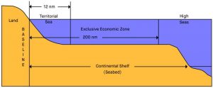
The maritime zones of a coastal state may typically consist of inter alia a territorial sea, exclusive economic zone and continental shelf (these are the necessary ones for the current discussion). These maritime zones are measured from a normal baseline, which is the low-water line (the level reached by sea water at low tide) along a state’s coast as marked on the large-scale charts officially recognised by that state.[2] Quite obviously, more land territory is revealed when the tide is low so it makes sense to not to end up trapping land when measuring a state’s sea. The waters found landward of state’s baseline are a state’s internal waters and seen as part of its territory.[3] The UNCLOS provides that a state may establish its territorial sea up to a limit not exceeding twelve (12) nautical miles (nm) from its baseline.[4] A state’s sovereignty extends beyond its land territory and internal waters to its territorial sea, its bed and subsoil as well as the airspace above it and is exercised subject to the provisions of the UNCLOS such as the duty to permit alien ships the right of innocent passage.[5]
A coastal state’s exclusive economic zone (“EEZ”) starts from the outer limit of its territorial sea but shall not extend beyond 200nm from the baselines from which the breadth of its territorial sea is measured.[6] A state has limited sovereignty rights and jurisdiction over its EEZ as compared to its territorial waters, however its rights extend inter alia to managing, exploring, exploiting and conserving natural resources (whether living or non-living) found on the seabed, in the subsoil of the seabed or in the water overlying the sea bed. Generally, a state has the right to commercially and economically exploit or explore its EEZ and the resources found therein to the exclusion of all other states e.g. only persons permitted by Ghana can fish in its EEZ. However, other states enjoy certain freedoms including inter alia the freedom of navigation in and flight over another state’s EEZ as well as the right to lay submarine cables and pipelines in it.[7]
A continental shelf refers to the natural extension/elongation of continental landmass into the sea, covered by a relatively shallow layer of water. A coastal state’s continental shelf is therefore a natural prolongation of its land territory into and under the sea. This landmass, depending on the geographical constitution of a location may extend underneath the water in a gradual slope or fall sharply, giving way to the ocean bed several thousands of metres underneath. The geographical extent of a continental shelf therefore varies depending on the location. The UNCLOS provides that a continental shelf of a state comprises the seabed and subsoil of the submarine areas that extend beyond its territorial sea throughout the natural prolongation of its land territory to a distance of 200nm from the baselines from which the breadth of its territorial sea is measured, or where the other edge of its continental margin extends beyond 200nm then a state’s continental shelf extends beyond 200nm but shall not exceed either 350nm from the baselines or 100nm from the 2500metre isobath (a line connecting to the depth of 2,500 metres), based on the recommendations for the outer limit by the Commission on the Limits of the Continental Shelf (“CLCS”).[8]
Thus, irrespective of whether a state’s geographical continental margin extends to 200nm from its baselines; it is entitled to a legal continental shelf of up to 200nm from its baselines. However, where its continental margin extends beyond 200nm, it can claim an extension to the outer limits of its continental shelf but subject to the restrictions stated above.
Ghana’s geographical continental shelf extends beyond 200nm and therefore it is entitled to an extended continental shelf, as does Côte d’Ivoire’s; that is why the judgment kept referring to the continental shelf within and beyond 200nm. Both states are currently in the process of delineating the outer limits of their continental shelves. Continental shelves are generally rich in oil and gas resources. Coastal states enjoy sovereignty rights over their continental shelves with respect to exploring and exploiting the natural resources found therein[9] and it is unlawful for a state to carry out drilling in another state’s continental shelf unless authorised by that state. That notwithstanding, a state’s rights over its continental shelf do not affect the legal status of the overlying waters or the airspace above those waters e.g. a state may own a continental shelf but the waters above that shelf may be classified as the high seas (high seas are free for all and cannot be appropriated by any state). Therefore, states cannot exercise their rights over their continental shelves in a way which infringes or unjustifiably interferes with the rights of other states to the water or air above it.[10]
The Dispute
The dispute concerned the delimitation of the maritime boundary between Ghana and Côte d’Ivoire. Explained in simple terms, it concerns agreeing on the specific limits of a state’s maritime entitlements just like neighbouring states know the limits of their landed territories and their respective boundaries. States with opposite or adjacent coasts are required to expressly agree on the limits of their respective territorial seas[11], exclusive economic zones[12] and continental shelves[13] to iron out geographical overlaps which may be sources of confusion and interfere with the exercise by states of the different bundles of rights they enjoy over these different maritime zones.
With relation to the territorial sea, in the absence of an agreement, neither state is permitted to extend its territorial sea beyond the median line, every point of which is equidistant from the nearest point on the baseline from which the breadth of the territorial seas of each of the two states is measured.[14] The UNCLOS further provides that the equidistance approach applies, unless historic title or other special circumstances make it necessary to delimit the territorial sea between two coastal states by a different approach.[15] This rule is regarded as having a customary law character and is referred to as the equidistance/special circumstances principle.[16] It means that unless some special circumstances are shown to exist between two states with adjacent coasts which warrant the use of a different method for delimitation, in the absence of an express agreement between the states, the default method to be used would be the equidistance method.
However with relation to the EEZ and continental shelf, the UNCLOS provides that the parties shall come to an agreement effected on the basis of International law as referred to in Article 38 of the Statutes of the ICJ[17] to achieve an equitable result, failing which they are to resolve the matter by recourse to the dispute resolution mechanisms provided for by the UNCLOS.[18] Côte d’Ivoire was making adverse claims to the continental shelf being claimed and exploited commercially by Ghana. The confusion was obviously because both states have adjacent coasts which they had not yet delimited. As they could not come to agree on the delimitation of their maritime boundary through negotiations, Ghana submitted the matter to the International Tribunal for the Law of the Sea (“ITLOS’’) for resolution.
Ghana’s Case
 Ghana claimed that although it had not expressly agreed on its maritime boundary with Côte d’Ivoire to delimit its territorial sea, EEZ and continental shelf, both parties had in practice respected a certain boundary arrived at using the equidistance methodology. The equidistance line, as explained earlier is a straight line drawn through the median point between the two nearest baseline points of both countries and projected seaward to delineate the maritime boundary. Ghana argued that this practice was inter alia evident in local Ivoirian legislation, Ivoirian charts and the fact that both states used this boundary for the allocation of oil concessions; with Ghana’s concessions lying west of this boundary and Ivoirian concessions lying east of the boundary. It therefore claimed that this practice was evidence of a tacit agreement creating a customary equidistance boundary binding on both countries (remember customary international law?). It stated that its primary aim before the ITLOS was not to seek the creation of a new boundary, but to have an authoritative declaration of the already existing customary boundary or in the alternative the creation of a boundary which conformed to the already existing boundary.
Côte d’Ivoire’s Case
 Côte d’Ivoire denied that a customary equidistance boundary existed. It stated that it had always objected to Ghana’s activities in the disputed maritime area (remember proof of protest is mostly fatal to claims of customary international law). It also claimed that the practice of both states allocating oil concessions on either side of the alleged boundary was because Ghana was first to establish its offshore petroleum block and therefore Côte d’Ivoire was constrained to establish its blocks in a manner so as not to overlap Ghana’s blocks. It claimed this was done out of restraint, caution and a desire to prevent instigating a conflict with its neighbour. In other words, there was no opinio juris i.e. underlying sense of legal obligation behind the practice nor did it recognise an equidistant boundary. It further claimed that Ghana had conducted oil exploration on its continental shelf and invoked Ghana’s international responsibility to make reparation to it for the wrongful exploration. It also requested for the creation of a maritime boundary based on a bisector approach instead of the equidistance approach. Its justifications for this methodology were inter alia that the concavity of the Ivorian coast as compared to the convexity of Ghana’s coast (i.e. although the coasts are adjacent each other, Ghana’s protrudes while Côte d’Ivoire’s has an indentation), the highly unstable nature of the Ivoirian coast i.e. the coasts shifted often made the equidistance method inappropriate. It also alleged that the location of the nearest base points for the determination of the equidistant line were in Jomoro, which was unfair to Côte d’Ivoire because Jomoro is a tiny strip of land which protrudes and blocks the massive Ivorian territory which sits atop of it from having access to the coast. It contended that these reasons as well as the fact that the Gulf of Guinea is subject to significant marine erosion called for a deviation from the use of the equidistance methodology.
The Decision
 The Special Chamber of ITLOS rejected Ghana’s claim of a customary equidistance boundary through a tacit agreement. It held that although the practice in relation to the alleged customary maritime boundary was consistent and mutual over a long period of time, it was not free of doubt or controversy. The standard of proof as earlier explained is very high and had not been met by Ghana because a tacit agreement is not easily presumed. Moreover, the chamber held that Ghana’s evidence of the custom consisted mostly in oil practice (behaviour in oil concession allocation, etc.) which alone is insufficient to prove a tacit agreement in relation to an entire maritime boundary. The reason was that a maritime boundary relates to all the maritime zones namely territorial sea, EEZ and continental shelf whereas the oil practice relates mostly to only the continental shelf. Also, oil practice can easily be explained by other factors and the Ivoirians advance a few plausible explanations such as the need for caution, restraint and good neighbourliness. Further, the Special Chamber held that the fact that both states had several exchanges and negotiations in attempt to delimit their maritime boundary was proof that there was no tacit agreement for a maritime boundary.
Despite its rejection of Ghana’s tacit agreement argument, the Special Chamber affirmed Ghana’s position on the use of the equidistance methodology to determine the boundary, thereby rejecting Côte d’Ivoire’s bisector methodology. The Panel found that in the absence of special circumstances, the default methodology ought to be based on equidistance and the arguments for a deviation from this methodology were unsatisfactory. It noted that Jomoro is part of the territory of Ghana, not a peninsula as the Ivoirians had argued. Accordingly, Jomoro could not be ignored in determining Ghana’s maritime entitlements without doing violence to the principle of Uti Possidetis (a public international law principle which frowns against refashioning of the established geographical boundaries of existing states). The Special Chamber also found as a fact that despite the Ivoirians claim that the coastline of the Gulf of Guinea was subject to significant erosion, the coastline from a British Admiralty Chart made in 1383 was very similar to the coast line depicted in a 2014 chart.
The Special Chamber went ahead to delimit the maritime boundary using the equidistance methodology but based on its own selected base points, rejecting the Ghanaian and Ivoirian base points as being too seaward and too landward respectively. The provisional equidistance line resulted in a cut off to the detriment of Côte d’Ivoire at 163nm (within the EEZ) but the Special Chamber held that it was inconsequential because all ships enjoy freedom of navigation in the EEZ and a good distance apart from the contested area which is not even 100nm from the baseline. There was thus no need to adjust the provisional equidistance line. The Special Chamber further delimited the boundary of the continental shelf beyond 200nm, pending each state’s delineation of the outer limits of its continental shelf. The disputed area was adjudged to fall within Ghana’s maritime zone.
With respect to Ghana’s international responsibility, it was held that Ghana was not in breach of International law, the UNCLOS or the Special Chamber’s order of 25th April 2015 (Ghana was ordered not to inter alia conduct new drilling pending the determination of the dispute) and therefore owed no duty to make reparation or pay compensation. More importantly, the Special Chamber held that where neighbouring states have a dispute over overlapping continental shelves, only an authoritative pronouncement on the delimitation establishes which portion of the continental shelf in dispute belongs to the disputing parties. Accordingly, the decision has a constitutive effect, not a declarative one. This means that maritime activities undertaken by a state in a contested area of the continental shelf which is held to belong to another state cannot be considered a violation of the sovereign rights of that other state, if the activities were carried out before the judgment and the area concerned was the subject of claims made in good faith by both states.[19] This pronouncement is very instructive, as it indicates that even if the disputed area had been held to be within Côte d’Ivoire’s continental shelf, Ghana’s prior hydrocarbon activities and exploration would not have amounted to an internationally wrongful act requiring Ghana to make reparation. Perhaps the only consequence would have been the future loss of revenue, not a debt to repay all accrued benefits from the exploitation. Fortunately, there will be no loss at all as the petroleum activities are in Ghana’s continental shelf.
[1] North Sea Continental Shelf Case ICJ Reports, 1986, p 109
[2][2] Article 5 of the 1982 UNCLOS.
[3] Ibid, article 8(1)
[4] Ibid, article 3
[5] Ibid, article 2
[6] Ibid, article 57.
[7] Ibid, article 58
[8] Ibid, article 76.
[9] Ibid, article 77(1)
[10] Ibid, article 78(1) & (2)
[11] Ibid, article 15
[12] Ibid, article 74
[13] Ibid, article 83
[14] Ibid, article 15.
[15] Ibid, article 15.
[16] See for example Qatar v Bahrain ICJ Reports, 2001 para.177
[17] supra
[18] UNCLOS, article 74 & 83.
[19] Dispute concerning delimitation of the maritime boundary between Ghana and Côte d’Ivoire in the Atlantic Ocean, Case No:23, delivered on 23/09/2017 para.592
PS: Images used in this write up were sourced from the ITLOS website and the respective memorials of Ghana and Côte d’Ivoire.
Leave a Reply